Constraints |
  
|
Constraints |
|
The Constraints Tab is where you set your constraint layers. The constraints are areas that have been identified during planning as an area that needs monitoring and cannot be affected by the harvesting activity. For example, riparian zones, protected streams, or archeological sites. Constraints show up as an additional red dotted line on the Profile graph so you can see the elevation of the constraint against the existing terrain.
Important Note: |
At version 1.4 of CHPS, the constraints have no impact on the payload calculations. The option to allow this will be added in a future version. If you need to determine if full suspension is possible over the constraint area, use your larding limits and other Profile settings (such as Full Suspension, or a Lift) to see what is possible. |
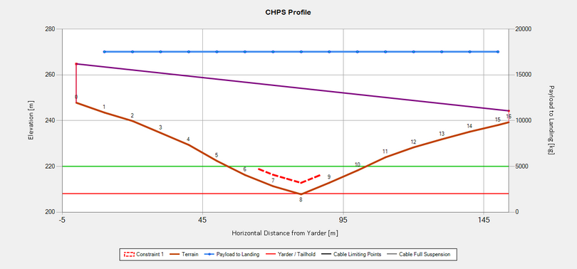
Profile Graph with a Constraint
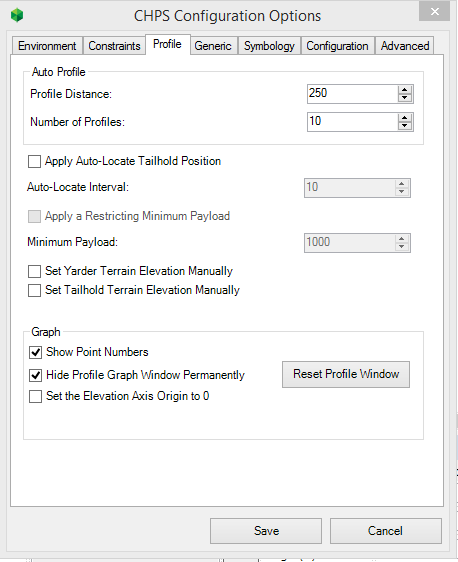
You can add up to three constraint layers to your configuration.
Important Note: |
All constraint layers must have a valid elevation value for CHPS to reference, if there is no elevation value the constraint wont be applied. The elevation value is not the absolute elevation for the constraint, but the relative value or additive value. So a value of 10m means that constraint effectively adds 10m to the existing elevation. |
When you expand the drop-down list, all Feature Classes loaded in your current ArcMap Table of Contents are available to chose from. If you don't want to use a constraint layer, you can leave the combo box blank or 'untick' the check box located to its right to disable it.
Once a feature class has been selected you need to specify the elevation field. To do this; Select the name of the field that stores the elevation value in your chosen Feature Class from the 'Elevation Field' drop-down box (located beneath the Layer drop-down)
Important Note: |
The section name states that it is aimed for constraint layers, you can use other feature classes as long as they have a field with valid elevation values. |
http://cableharvesting.com/help//5-The_Interface.The_Toolbar.Options.Constraints.htm
Topic Last Updated: Tuesday, 13 September 2016