Profile |
  
|
Profile |
|
The Profile Tab enables you to set options for drawing Profiles and setting the display in the Profile Window

An explanation of each of the Auto Profile configuration options is below;
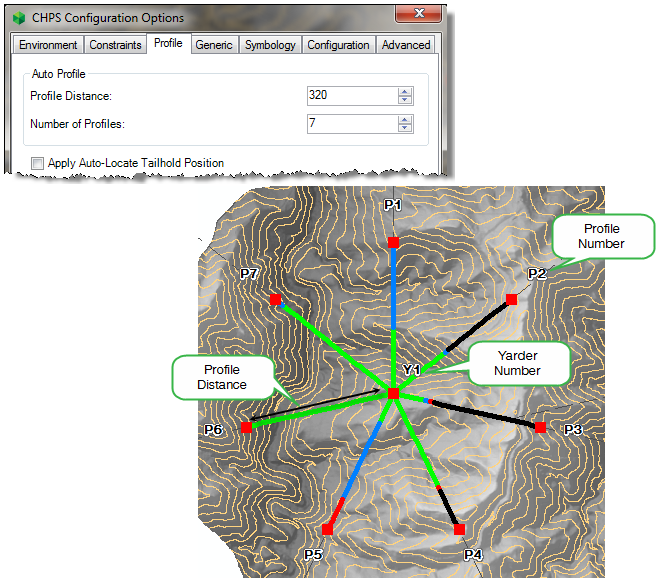
Profile Distance |
This sets the initial horizontal distance for each Profile drawn by the Create Auto Profiles tool
|
Number of Profiles |
This sets the number of Profiles drawn in each Profile group by the Create Auto Profiles tool |
An explanation of each of the Profile Drawing options is below;
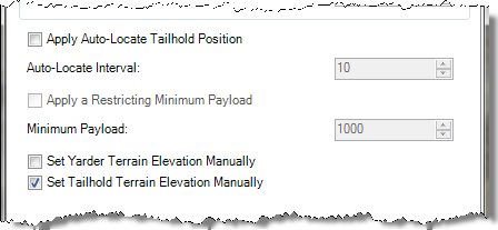
Apply Auto-Locate Tailhold Position |
This options allows CHPS to automatically locate a Tailhold position along the Profile line you have drawn if the Profile has no solution. CHPS will start at the Tailhold location nominated, and work back towards the Yarder until a solution is found. Note: This applies to the Create Auto Profiles Tool as well. Note: That CHPS will only use the Auto Locate feature once for each Profile. If you then manually change the position of the Tailhold, it will not auto locate. There is an option on the CHPS Control Panel to re-apply the auto locate function to a selected Profile if required.
|
Auto-Locate Interval |
The Auto-Locate Interval text box is available when the 'Apply Auto-Locate Tailhold Position' option is enabled. This interval defines the distance which the Auto-Locate tool moves the Tailhold in every attempt to find a solution.
|
Apply a Restricting Minimum Payload |
The 'Apply a Restricting Minimum Payload' option is available when the 'Apply Auto-Locate Tailhold Position' option has been enabled. The user defines a minimum acceptable payload eg 2000kg to be used by the Apply Auto-Locate Tailhold Position tool. This means that the Auto-Locate Tailhold tool will attempt to find a solution with a payload 'equal to' or 'greater than' the restricting minimum payload.
|
Set Yarder Terrain Elevation Manually |
With this option enabled the user will be prompted to insert the Yarder terrain elevation when a Yarder is drawn on the map and there is no elevation data available at the Yarder's location. This option is only available when the Elevation Data Source is Contour Data.
|
Set Tailhold Terrain Elevation Manually |
With this option enabled the user will be prompted to insert the Tailhold terrain elevation when a Tailhold is drawn on the map and there is no elevation data available at the Tailhold's location. This option is only available when the Elevation Data Source is Contour Data. |
An explanation of each of the Profile Window Options is below;
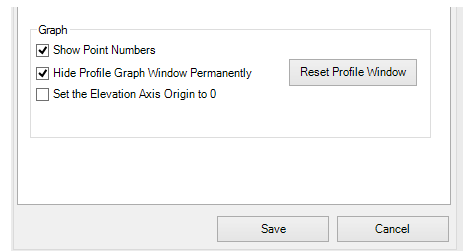
Show Point Numbers |
Turn on or off the the terrain point labels in the Profile Window
|
Hide Profile Graph Window Permanently |
Disables the Profile Window. It will not be pop up when Profiles are selected. This can be useful when you are in the process of creating many Profiles and are not yet ready to begin reviewing the Profiles and running your analysis. It can also be useful in this case if you have only one Monitor.
|
Set the Elevation Axis Origin to 0 |
This sets the elevation axis origin in the Profile Window to '0'. This option is normally used if you would like to see the terrain relative to sea level (0). Note that this will significantly change the size of the Profile graph (essentially squeezing it vertically) and it may not be very easy to see the detail of the terrain and the payload graph etc. |
Reset Profile Window button |
Resets the location of the Profile Window to its default location - floating in the middle of the primary screen. |
http://cableharvesting.com/help//5-The_Interface.The_Toolbar.Options.Profile.htm
Topic Last Updated: Tuesday, 13 September 2016