Generic |
  
|
Generic |
|
Options in the Generic tab;
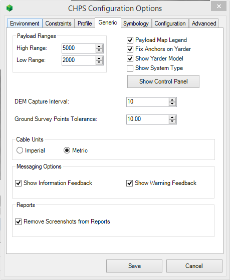
Payload Ranges - (High/Low Range) |
This specifies the high and low range used to symbolise the Profiles on the map. The ranges are reflected in the floating 'Net Payload to Landing' Legend You can define the colours used to represent the ranges the 'Symbology tab'
|
||
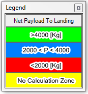
Payload Map Legend |
This turns on and off the floating 'Net Payload to Landing' Legend
|
||
Fix anchors on Yarder |
This option specifies the behavior of the Tailholds for a Profile Group when the Yarder is moved. •If this option is enabled when the Yarder is dragged and dropped on another location in the map the Tailholds will remain in the exact same location. •If this option is disabled the Tailholds location will move relatively with the Yarder.
|
||
Show Control Panel button |
Resets the location of the control panel to its default location - docked at the bottom of the primary screen. |
||
Show Yarder Model |
This specifies whether the Yarder Model is shown next to the Yarder Name in the Tree View |
||
Show Cable System |
This specifies whether the Cable System (eg Running Skyline) is shown next to the Profile Name in the Tree View |
||
DEM Capture Interval |
It defines the interval distance where the Profile will generate a Terrain Point on a Profile when working with a raster DEM (Digital Elevation Model). When the value its 0 the application uses half of the spatial resolution of the pixel as an interval. For example, if the size of DEM pixel is 25 x 25 m. and the interval is set to 0, the application will use 12.5m, which is half of the spatial resolution of the pixel. Generally you would set this to be a value of 5 or 10m.
|
||
Ground Survey Points Tolerance |
Defines the distance where the Ground Survey Points affect the Profiles. If the ground survey point is within this distance of a Profile, then CHPS will use the ground survey point for the elevation.
|
||
Cable Units |
Set the DISPLAY units the Cable will use, either Metric or Imperial. This is only used to alter the way the Cable names are displayed and has no impact on the payload calculation and map units. This was implemented to cater for users who are using Metric units but still refer to ropes and Cables using their Imperial size e.g. 1in Swagged. |
||
Messaging Options |
These checkboxes control whether non-error Profile Messages are shown to the user. Note: Hiding these messages might prevent information about Profiles from being shown to the user. |
||
Remove Screenshots from Reports |
Ticking the checkbox will omit screenshots of the profiles on the map from the generated report. |
http://cableharvesting.com/help//5-The_Interface.The_Toolbar.Options.Generic.htm
Topic Last Updated: Tuesday, 13 September 2016